Multispectral WebGL
Iván Sánchez Ortega
Brief bio
- Nerd
- CompSci dropout
- Bought a GPS in 2006
Prelude
I don't like Zoom.
Not FLOSSy, security & data privacy concerns
Try Jitsi.org!
color colour
Spectrum visible colour bands

Whole spectrum
Chapter I:
GIS vs videogame tech*
Both fields are multidisciplinar within CompSci
|
|
Both fields have acronyms that make no sense
EPSGEuropean Petroleum Survey Group
Datum-Projection code |
VBOVertex Buffer Object
Attribute Write-Only Memory Allocation |
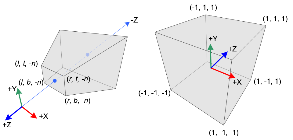
Both fields have weird coordinates
|
|
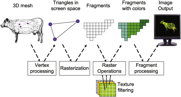
In both, pixels are more than RGB
|
|
In both cases, the (RGB) colour in the screen is a function of the data for each pixel...
...so videogames are doing raster algebra, after all.
https://www.shadertoy.com/view/Mdl3WH
The big difference
|
GIS → Accuracy
«Acc worse than 0.5cm is
|
Games → Speed
«OMG this game doesn't run at 60FPS 4K on my 100Hz HDR 46' ultrawide screen»
|
Convergence & opportunity
GIS is faster because tiles
|
GPUs are more accurate because convolution-driven neural networks to perform image recognition on cat photos
|
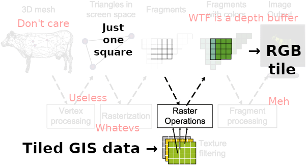
Sweet spot:
- Get a raster tile...
- ...with several 8- or 16- or 32-bit data samples per pixel...
- ...put it into a texture...
- ...and let the GPU turn those texture(s) into a RGBA colour value
Videogames have been doing raster algebra better and a hundred times faster than any GIS software for years.
Challenges
GIS has a lot of baggage
|
GL tech is deeply entrenched in high-level frameworks
|
Chapter II:
The secret to hacking web maps
- Analysis
- Morphosis
- Synthesis
- Break it up
- Change a part
- Put it back together
- Be aware of all the moving pieces
- Change one specific moving piece
- Ensure everything keeps moving together


State of the art
Working proofs-of-concept:
- Leaflet.TileLayer.GL
- WebGL1, max 8 RGBA 4×8-bit textures
- Leaflet.TileLayer.GL2
- WebGL2, max 8 2048×2048×2048 float-32 data cubes
- geotiff.js support
- OpenLayers' GlTiles tile source
- WebGL1, max 8 RGBA 4×8-bit textures
- geotiff.js support for 8-bit geotiffs
- Really soon™: Uint16 support via byte packing
Issue: In-CPU resampling
- GeoTIFF tiles BBOXes are relative to GeoTIFF BBOX
- GeoTIFF tiles don't fit (pseudo-)WMTS tiles
- Resampling needed
Approach 1: Skip reusing tile schemes
- Tile bbox queries for geotiff.js?
- In-GPU resampling?
- Redo tile visibility logic
Approach 2: WebGL in geotiff.js
- Improve geotiff tile caching
- Blind WebGL development
- In-geotiffjs shaders (at least for resampling methods)